
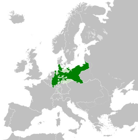
Dosiero:Kingdom of Prussia 1870.svg

Grando de tiu PNG antaŭprezento de tiu SVGa dosiero: 450 × 456 rastrumeroj. Aliaj distingivoj: 237 × 240 rastrumeroj | 474 × 480 rastrumeroj | 758 × 768 rastrumeroj | 1 011 × 1 024 rastrumeroj | 2 021 × 2 048 rastrumeroj.
Fonta dosiero (SVG-dosiero, 450 × 456 rastrumeroj, grandeco de dosiero: 705 KB)
Resumo


.svg)
.svg)
.svg)
.svg)
.svg)


.svg)
.svg)
.svg)


.png)
.png)


.svg)


.svg)

.svg)


.svg)
.svg)
.svg)
.svg)


.svg)
.png)


.svg)


.svg)
.svg)


.svg)


.svg)


.svg)
.svg)
.svg)
.svg)
.svg)
.svg)
.svg)
_cropped.svg)
.svg)
.svg)
.svg)
.svg)
.svg)
.svg)
.svg)
.svg)
.svg)
.svg)
.svg)
.svg)
.svg)
.svg)
.svg)
.svg)
.svg)
.svg)
.svg)
.svg)
.svg)
.svg)
.svg)
.svg)
.svg)
.svg)
.svg)
.svg)
.svg)
.svg)
.svg)
.svg)
.svg)
.svg)
.svg)
.svg)
.svg)
.svg)
.svg)
.svg)
.svg)
.svg)
.svg)
.svg)
.svg)
Permesiloj:
Ĉi tiu dosiero disponeblas laŭ la permesilo Krea Komunaĵo Atribuite-Samkondiĉe 4.0 Tutmonda.
- Vi rajtas:
- kunhavigi – kopii, distribui kaj publikigi la verkon
- aliigi – modifi, adapti, kompletigi, transformi, uzi la tutan verkon aŭ ties partojn, memstare aŭ en aliaj verkoj
- La verko rajtas esti kunhavigata nur:
- atribuite – Vi devas atribui aŭtorecon, liveri ligilon al la permesilo kaj marki ĉu ŝanĝoj estis faritaj. Faru tion en aprobinda maniero, tamen ne sugestante, ke permesinto aprobas vin aŭ vian uzon.
- samkondiĉe – Se vi rekombinas la verkon, transformas ĝin aŭ kreas devenaĵon bazitan sur ĝi, vi rajtas distribui la rezultan verkon nur laŭ la sama aŭ kongrua permesilo kompare kun ĉi tiu.
Dosiera historio
Klaku daton/tempon por vidi la dosieron kia ĝi aspektis tiam.
| Dato/tempo | Bildeto | Dimensioj | Uzanto | Komento | |
|---|---|---|---|---|---|
| nuna | 02:54, 1 jun. 2016 | | 450 × 456 (705 KB) | Alphathon | Various corrections to the states of the North German Confederation |
| 05:22, 31 maj. 2016 |  | 450 × 456 (662 KB) | Alphathon | Minor corrections (Tarasp and post-1818 German Confederation border change) | |
| 02:40, 31 maj. 2016 |  | 450 × 456 (662 KB) | Alphathon | == {{int:filedesc}} == {{Inkscape}} {{Information |Description={{en|A map of the en:Kingdom of Prussia within the North German Confederation and within Europe circa 1870 CE.}} |Source= {{Derived from|Blank_map_of_Europe.svg|display=50}} |Da... |
Dosiera uzado
La jena paĝo ligas al ĉi tiu dosiero:
Suma uzado de la dosiero
La jenaj aliaj vikioj utiligas ĉi tiun dosieron:
- Uzado en af.wiktionary.org
- Uzado en ar.wikipedia.org
- Uzado en bn.wikipedia.org
- Uzado en ckb.wikipedia.org
- Uzado en en.wikipedia.org
- Uzado en es.wikipedia.org
- Uzado en es.wiktionary.org
- Uzado en eu.wikipedia.org
- Uzado en fa.wikipedia.org
- Uzado en fi.wikipedia.org
- Uzado en he.wikipedia.org
- Uzado en hu.wikipedia.org
- Uzado en is.wikipedia.org
- Uzado en it.wikipedia.org
- Uzado en li.wiktionary.org
- Uzado en lld.wikipedia.org
- Uzado en lt.wikipedia.org
- Uzado en mn.wikipedia.org
- Uzado en pl.wikipedia.org
- Uzado en rue.wikipedia.org
- Uzado en ru.wikipedia.org
- Uzado en ru.wiktionary.org
- Uzado en sk.wikipedia.org
- Uzado en szl.wikipedia.org
- Uzado en tr.wikipedia.org
- Uzado en uk.wikipedia.org
- Uzado en uz.wikipedia.org
- Uzado en xmf.wikipedia.org
- Uzado en zh.wikipedia.org